 Xbox One
 PC
PC Mobile device
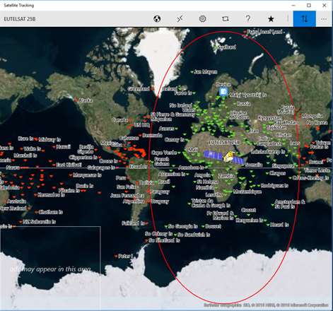

Information
English (United States)
Description
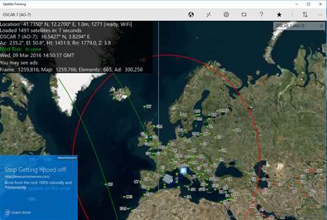
See the location of the International Space station and all other earth orbiting satellites.
Did you know the brightest man-made object orbiting the earth is the International Space Station?
And, did you know it is very easily seen on a clear night?
With the Satellite Tracking application, you can determine when the space station or other satellites are visible from your location for viewing or communicating.
There are over 1400+ satellites currently orbiting Earth.
Some of these include amateur radio, Hubble space telescope, GPS, navigation, communication, earth and science, spy, classified, scientific, plus many more!
The Satellite Tracking application features include:
Notifications. Road globe projection. Maidenhead grid square and distance between two stations and great-circle. Es'hailsat 2 launch preparation keplerians. Show all geo satellites at same time on equator - click to track Show antenna direction line to satellite - deep zoom 2D or 3D map (road, aerial, terrain) Zoom in and out on maps User and satellite position icons Satellite footprint Satellite future location GPS location service or manually entered position # of satellites loaded from the internet Satellite designator and sub-satellite position Azimuth and elevation from your position Height above earth Range from your location Countdown timer for next rise at your location GMT date display Satellite category and selection Settings for map style Setting for map centering on user, satellite, or free roaming map Location override to manually enter your position Equator, date-line, and prime-meridian lines on map Share your map and position data to popular social media and other applications registered on your system such as Twitter, mail, etc. Help documentation and tool-tips to aid in your usage Toggle switch to allow position information to be displayed on map or not for pure-view map examination Orbit information such as catalog number, latitude, longitude, elevation, azimuth, range, height, orbit #, phase, next rise, period, and footprint radius For given category, show all satellites currently in view or all Future passes showing date and time, azimuth, and elevation Radio communication frequency bands, links, and modes to use for Amateur Radio satellites Keplerian information such as catalog number, epoch orbit, epoch year, epoch day, raan right ascension of node, eccentricity, mean anomaly, mean motion, and decay rate Application details shown in about, perform an application review, ask for support if need, send feedback, or view other applications written by the authors DXCC countries can be shown on the map DXCC calculator to show what countries can be communicated to via the satellite
Perhaps you want to spot the station, get current position of ISS, or ask yourself where is the international space station?
The following categories of satellites can be selected:
Amateur Brightest Communication Earth-weather Geo-sync Miscellaneous Navigation New Old Scientific Stations
These are just some of popular satellites to track:
Amateur OSCAR 7 (AO-7) UOSAT 2 (UO-11) LUSAT (LO-19) EYESAT-1 (AO-27) ITAMSAT (IO-26) RADIO ROSTO (RS-15) JAS-2 (FO-29) TECHSAT 1B (GO-32) ISS (ZARYA) FUNCUBE-1 (AO-73) UWE-3 SPROUT DUCHIFAT-1 CHUBUSAT-1 NUDT-PHONESAT XW-2A XW-2B XW-2C XW-2D XW-2E XW-2F LILACSAT2 DCBB AO-85 FOX-1A
Brightest ATLAST CENTAUR 2 THOR AGENA SL-3 SL-8 R/B CUSAT 2 & FALCON 9 R/B
Communication MOLNIYA O3B
Earth-Weather NOAA GOES TDRS SCD HST Hubble Space Telescope METEOSAT
Geosynchronous DIRECTV SKYNET INTELSAT NATO OPTUS ASTRA AMSC ECHOSTAR MSAT PALAPA Eshailsat INMARSAT EUTELSAT GALAXY SUPERBIRD BRASILSAT CHINASAT THOR SIRIUS AFRISAT ASIASAT TELKOM HISPASAT ASIASTAR TURKSAT SAUDISAT SPACEWAY BADR FENGYUN ZHONGXING
Misc. CALSPHERE LCS OPS FLOCK CENTENNIAL
New EXPRESS GAOFEN 2015-49A
Old ATLAS CENTAUR 2 THOR SL-3 R/B
Scientific STARLETTE HST MMS
Stations ISS International Space Station ZARYA
Enjoy the galaxy and look for those shooting-stars as all kids do!
Privacy Policy: Location data is stored within the application and is only used for satellite position calculations. You can turn off usage of your position in settings.
Functional Policy: Accuracy of positions calculations are not guaranteed.
People also like
Reviews
-
12/29/2017Windows 10 -- now supporting Multi-Sat tracking! by Karhu
With the latest update, you can now track multiple satellites at the same time! Let us know if you have other feature wants. Best regards, Karhu.
-
12/21/2015Now working by Gary
Update: I uninstalled the app, then reinstalled it and it is working properly again. Comprehensive, but a little cumbersome to use. Good app though. If it keeps working properly I will buy it. It used to work, but now it won't open after the last couple of Windows 10 updates.
-
8/29/2015Very nice by Unknown
Beautiful interface. Well over a thousand satellites and easy to update. Beware of very high CPU usage the first time you run it ... it ate a lot of battery and heated up the CPU for several minutes. Then it calmed down.
-
11/21/2016by samj
Excellent
-
10/17/2015Missing new satellite, no search function by LDS
AO-85 was launched over a week ago and still doesn't show up in the catalog as far as I can tell. The list of satellites that are available to track appear to be sorted by NORAD catalog index in descending order, but there is no way to search by common name or even sort by common name making it difficult to find. An alert function to warn you that a specific satellite is about to come into view would be very useful.
-
7/17/2017Track pack, and locate it jack. by julius
Easy to use, very educational, Wish more leads of descriptive study, and guide would be offered. There always seem to be more than meets the eye. I love it. It's my favorite app.
-
12/25/2016As a ham radio operator, this is quite handy. by Robert
This is a really nice app. It is a great way to track amateur radio satellites. It looks like a great way to display sats projected on a large screen for presentations.
-
11/6/2016Very Nice by Dave
I use this software to track NOAA 15-18 &19 weather satellites for my weather sat. station. The display is great & the info is spot on. It's worth it.
Articles
Top downloads
- 1
Duolingo - Learn Languages for Free
Free
- 2
T-Translator
Free
- 3
Optical Illusions
Free
- 4
VoiceTranslator
Free
- 5
My Study Life
Free


New and rising apps
- 1
Driving Theory Test
$4.49
- 2
Hazard Perception Test UK
$2.49
- 3
Driving Theory Test UK
$1.99
- 4
1 Learn Sight Read Music Notes - Solfa
$1.49
- 5
German - Czech
$1.79
- 6
CorelDRAW Graphics Suite X7 Tutorials
$1.99
- 7
World Atlas & Quiz MxGeo Pro
$2.49
- 8
German English dictionary ProDict
$2.99
- 9
Zulu English dictionary ProDict
$2.99
- 10
Deutsche Gedichte
$0.99


Best-rated apps
- 1
Chestionare auto - Scoala Auto
$1.49
- 2
DK Print your own T. Rex
Free
- 3
Learn Spanish
$11.99
- 4
Kent Hovind Seminars
Free
- 5
MakeCode for micro:bit
Free
- 6
Snap + Core First Full
$179.99
- 7
Bulgarian - English
$1.79
- 8
Guitar Chord Groups
Free
- 9
Root Solver
Free
- 10
Snap + Core First
Free


Best-rated games
- 1
Sudoku Play & Solve
$0.99
- 2
BoxEmoji
Free
- 3
Drift Mania Championship
$0.99
- 4
Ball don't fall
$1.99
- 5
Hidden Object : Film Ready Action
$1.99
- 6
2 Pics 1 Word - Free
Free
- 7
Hidden Object : Hollywood Crime
$1.99
- 8
Nuclear Warfare
Free
- 9
Funtoon's World HD
Free
- 10
Debonair
Free