 Mobile device
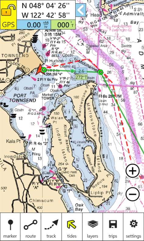

Information
English (United States)
Description
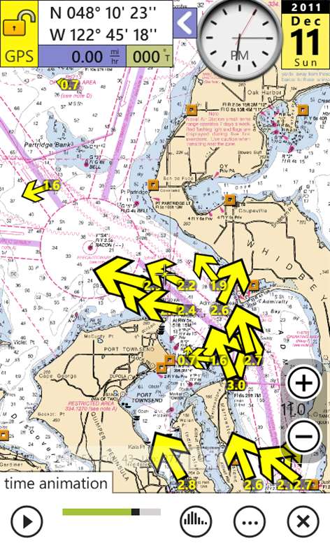
NOAA nautical charts with animated tides and currents, markers, routing, and tracks. Charts cover the entire USA coastline. Use GPS to map your location, plan a course, mark locations, and show tides and currents. The perfect boating and sailing companion.
People also like
Reviews
-
9/30/2013by lu
Can not use without data offshore.Worthy to buy when download maps will be added.
-
6/15/2014by Matthew
Really nice app with a great set of features. Would like cached or downloadable maps!
-
8/15/2014by Kevin
This is my favorite WP8 app on Nokia my 1020. Great tip from Teddy on going black fix...set Opacity all the way right and Base Layer to None. You can zoom in more than you need. Just took 28 mile trip from Wrightsville Beach to Bald Head Island and didn't even bring Garman along.
-
7/2/2014by Teddy
Likely all I will ever need. And for 10 bucks? Astounding. "Going Black" at upper magnification. Try fooling with the "Layers", "Base Layer" - especially, "Chart Layer Opacity"... Try varying settings on the Road(Plain) Map, Aerial(Photos) and just the Chart. On "CHART", setting Base Layer to NONE, and Chart Layer Opacity, all the way to the right(Most Pink). I can zoom all the way past the 'usable' resolution for the chart, itself! Try varying Chart Layer Opacity, making it "less bright", for night use. ALSO: Turn on "Prevent Screen Lock", so screen doesn't go off while NC is in use(Watch your battery level! Turn off/on manually, as needed.). Aerial View, set right, will zoom past its' "clear picture"(Though still "usable") resolution, too! Cool as it gets! Thankx Nomad folks!
-
2/16/2016by Steve
Still don't know how to use it very well, but I'm a commercial charter captain and GPS died. Downloaded this at anchor, and have been using it for days getting us home and impressed with the app as GPS backup.
-
7/26/2015by Steve
Fantastic tool for all types of boaters. Current animation is incredibly helpful.
Articles
Top downloads
- 1
Windows Maps
Free
- 2
gMaps
Free
- 3
GPS Satellite
Free
- 4
MapQuest
Free
- 5
GPS Voice Navigation
Free


New and rising apps
- 1
Stars 3D
$1.49
- 2
NAVIGON Europe
$80.49
- 3
Paris ci la Sortie
$0.99
- 4
SeaMap
$0.99
- 5
Outdoor Navigation
$4.99
- 6
Amsterdam Metro
$0.99
- 7
Altimetro
$0.99
- 8
FirstMate
$4.99
- 9
Bicing Barcelona
$1.49
- 10
City Maps - Vienna
$0.99


Best-rated apps
- 1
Transit Indianapolis
$1.99
- 2
myLocation
$0.99
- 3
Reitit
Free
- 4
Street Views
Free
- 5
MyLocation
Free
- 6
SatelliteMap
$4.99
- 7
Compass
Free
- 8
Geo Converter (Lite)
Free
- 9
Photo Editor India
Free
- 10
Road Trips
Free


Best-rated games
- 1
Sudoku Play & Solve
$0.99
- 2
BoxEmoji
Free
- 3
Drift Mania Championship
$0.99
- 4
Ball don't fall
$1.99
- 5
Hidden Object : Film Ready Action
$1.99
- 6
2 Pics 1 Word - Free
Free
- 7
Hidden Object : Hollywood Crime
$1.99
- 8
Nuclear Warfare
Free
- 9
Funtoon's World HD
Free
- 10
Debonair
Free