
 Mobile device
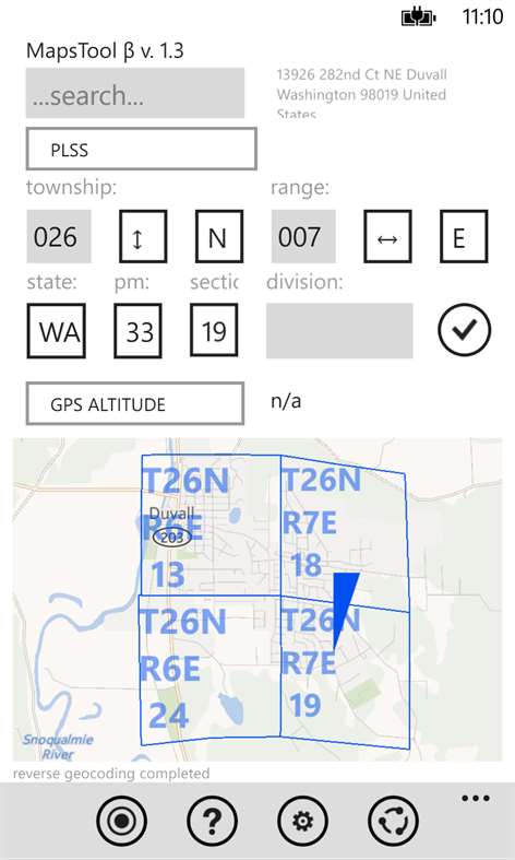

Information
English (United States) 日本語 (日本) Русский (Россия)
Description
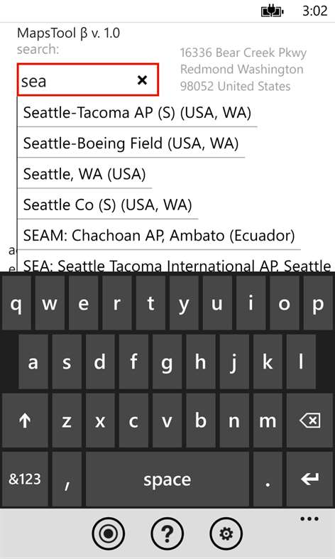
Maps Tool is a powerful app that allows you to convert data between many coordinate system representations and also adjust for various datum. This app currently supports lat/lng, UTM, MGRS, Earth-centered, Earth-fixed Cartesian coordinate system, Swedish Grid, Ordnance Survey of Great Britain and Irish National Grid and many different geodetic datums, including, but not limited to: WGS 84, NAD 27, ED 50, ETRF 89, OSGB 36, OSI 65, RT 90, SWEREF 99, SIRGAS 2000, SAD 69, Córrego Alegre, SICAD, Astro Chuá and SK 42. By default Maps Tool uses offline HERE+ maps already stored on your phone, but can also use Bing Maps, Google Maps, and OpenStreetMaps for better coverage. Overlays such as topographic map and satellite imagery are also available. Other handy function of Maps Tool include geocoding (finding location by address) and reverse geocoding (find closest address for a given location), sharing your location via sms/email and build-in database of around 3000 major cities and 9000 world airports for quick access (you can just key in a 3-letter IATA or 4-letter ICAO code). Using web service from BLM (Bureau of Land Management) Maps Tool also gives you access to PLSS (Public Land Survey System) information (township, range, section) as a convenient map overlay (you can search for parcels by TRS or view parcels around you by tapping on the map). Last but not least, Maps Tool app allows you to see rough altitude information from the GPS module in your phone, or (available as an optional download) query various GIS systems for accurate topographical altitude information including currently supported: USGS (US only), SRTM3, GTOPO30, ASTER and Google. Best of all this app does not require a data connection to work, so you can take it with you into the field.
People also like
Reviews
-
10/8/2015by Peter
Good coordinates locator. Integrates well with BLU phone.
-
3/28/2015by Med
Excellent App reviewed by a surveyor
-
6/30/2014by Ruslan
I happy to find the app I need. With high requirements to maps application I tried different apps for WP8 and was very disappointed but MapsTool made me happy. Thanks!
-
6/5/2014by Oleg
Useful app with many different settings and metrics.
-
5/25/2014by Personal
Great app for those that fall into a situation where they are ask to provide the address when you have no idea where about you are. Great Job!!!
-
5/24/2014by Christos
I love seeing for the first time that my house is at 629 ft altitude
-
5/24/2014by Gordon
Very impressive
Articles
Top downloads
- 1
Windows Maps
Free
- 2
gMaps
Free
- 3
GPS Satellite
Free
- 4
MapQuest
Free
- 5
GPS Voice Navigation
Free


New and rising apps
- 1
Stars 3D
$1.49
- 2
NAVIGON Europe
$80.49
- 3
Paris ci la Sortie
$0.99
- 4
SeaMap
$0.99
- 5
Outdoor Navigation
$4.99
- 6
Amsterdam Metro
$0.99
- 7
Altimetro
$0.99
- 8
FirstMate
$4.99
- 9
Bicing Barcelona
$1.49
- 10
City Maps - Vienna
$0.99


Best-rated apps
- 1
Transit Indianapolis
$1.99
- 2
myLocation
$0.99
- 3
Reitit
Free
- 4
Street Views
Free
- 5
MyLocation
Free
- 6
SatelliteMap
$4.99
- 7
Compass
Free
- 8
Geo Converter (Lite)
Free
- 9
Photo Editor India
Free
- 10
Road Trips
Free


Best-rated games
- 1
Sudoku Play & Solve
$0.99
- 2
BoxEmoji
Free
- 3
Drift Mania Championship
$0.99
- 4
Ball don't fall
$1.99
- 5
Hidden Object : Film Ready Action
$1.99
- 6
2 Pics 1 Word - Free
Free
- 7
Hidden Object : Hollywood Crime
$1.99
- 8
Nuclear Warfare
Free
- 9
Funtoon's World HD
Free
- 10
Debonair
Free