 Mobile device
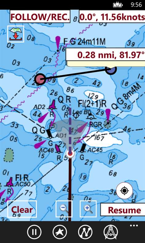

Information
English (United States)
Description
This App offers offline nautical charts, lake & river navigation maps for fishing, kayaking, boating and sailing. Coverage includes marine vector charts, freshwater lake maps, and inland river maps (HD/1ft/3ft bathymetry included where available). First marine GPS app to have route assistance with Voice Prompts for marine navigation. You can create new boating routes or import existing GPX/KML routes. It supports Nautical Charts course up orientation. Includes Tide & Currents prediction.
►FEATURES √ Beautiful and detailed Hardware/GPU accelerated vector charts (text stays upright on rotation) √ Query details of Marine object (Buoy, Lights, Obstruction etc). √ Customizable depth(Ft/Fathom/Meter) and distance units (km/mi/NM) √ Customizable Shallow Depth. √ Record tracks, Autofollow with real-time track overlay & predicted path vector. √ Voice Prompts for marine navigation (requires GPS ) √ 1ft / 3ft depth contour maps for anglers for selected lake maps. √ Supports GPX/KML for boating route editing/import. √ Tide & Currents prediction. √ Seamless chart quilting. Map details from Coastal, Approaches,Harbour, Inland Encs(rivers), and general ENC charts are automatically mapped to correct zoomlevel √ Enter or import Waypoints.
► MAPS Get all the details that you find in your chart plotters! (More regions are added every week) Please check website. Includes unlimited updates for 1 year. √USA: Maps include coverage of all NOAA ENC, USACE inland river maps, and freshwater lake maps for more than 7K lakes. Charts include HD/1ft/3ft bathymetry where available. Also includes NOAA raster charts for areas where NOAA ENC coverage is not available. √Canada: Derived from CHS data including rasters for some regions. Includes maps for Great lakes(US & Canada sides), Alberta & Ontario lakes, Lake Simcoe, and Trent Severn Canal. √UK/Ireland: Includes data derived from UKHO charts √Europe Inland River/Waterways √Argentina √Malta, Cypress, Crete & South Mediterranean √Malaysia and South China Sea √Germany √Denmark √Russia - Inland Rivers & Waterways (incl. Volga river) √Persian/Arabian Gulf, Red Sea & Gulf of Aden √Netherlands: Charts include NLHO ENC and Inland River ENCs. √Norway √Brazil √Spain √Australia √New Zealand √Ukraine(Black Sea) √Croatia √Caribbean √South Africa √Sweden √Malta √Finland
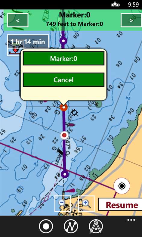
►ROUTE MANAGEMENT / TRIP PLANNING √ Create New Route/Edit Routes √ Reverse Routes √ Enter,Move, Add, Delete, Rename Waypoints √ Import GPX, KML & KMZ files √ Plot/Edit Routes √ Share/Export Routes, Tracks & Markers
►GPS FEATURES √ Auto Follow * Real Time Track Overlay * Predicted Path Vector * Course Up (Text stays upright) * Speed & Heading √ Route Assistance With Voice Prompts * Prompts when approaching a boating route marker * Continous distance & ETA updates * Alerts when sailing/boating off route * Alerts when boating in wrong direction √ Record Tracks
►TIDE & CURRENTS * For US, Canada, UK, Germany & New Zealand * High/Low Tides * Tidal Current Prediction * Active Current Stations
► SHARING * Share tracks/routes/markers on Facebook & Twitter * Export tracks/routes/markers as compressed GPX files.
Sample Nautical Charts (See http://gpsnauticalcharts.com/main/folio-catalog-nautical-charts-app for complete list) ... USA: Texas lakes: Eufaula, texoma Florida lakes: Okeechobee Massachussets lakes: Quabbin Wisconsin Lakes: Winnebago Minnesota lakes- Minnetonka, Waconia,Leech,Mille Lacs Maine: Sebago Alaska: Winnipesaukee, Ontario, Huron, Erie, Michigan, Superior TAMPA BAY CHESAPEAKE BAY CAPE CHARLES-NORFOLK HARBOR ANCLOTE KEYS-CRYSTAL RIVER MIAMI HARBOR Keowee,Jocassee,Hartwell,Greenwood,Lake Murray Rainy Lake Quebec to Anticosti Island West Gulf of St. Lawrence South Newfoundland East & South Great lakes Canada & St. Lawrence river Manitoba & Saskatchewan Georgian Bay Gulf of St. Lawrence North-Newfoundland West Puget Sound north sea pacific ocean KEY WEST-MISSISSIPPI SAN PEDRO LAKE MICHIGAN STONY LAKE-POINT BETSIE APALACHICOLA BAY-CAPE SAN BLAS MONHEGAN ISLAND-CAPE ELIZABETH SAN FRANCISCO MIAMI-MARATHON BLACKBURN HURON TAHOE
Canada : Lac Saint Jean Ontario Lakes Rideau Canal- Ottawa River British Columbia Pacific Coast- Vancouver- Haida Gwaii Nova Scotia South- Bay of Fundy
United Kingdom / Ireland: BRISTOL CHANNEL & SOUTH IRELAND ENGLAND S COAST & SCILLIES IRELAND W C-KENMARE R-FORELAND IRISH SEA N&E SCOTLAND-LEWIS-FORTH-N ISLES NORTH SEA-FORTH-THAMES ENTRANCE SCOTLAND KINTYRE-LOCH BROOM THAMES-MEDWAY & APPROACHES
Popular charts/Folios: Rainy Lake and Lake of the Woods Quebec to Anticosti Island West Gulf of St. Lawrence South Ontario Lakes Trent-Severn Waterway Labrador Coast Lac Saint Jean Rideau Canal - Ottawa River Georgian Bay Newfoundland East and South Great lakes Canada and St. Lawrence river Lakes and Rivers in Manitoba and Saskatchewan Lakes and Rivers of British Columbia Pacific Coast - Vancouver Island East & West - Haida Gwaii Lakes around Georgian Bay Gulf of St. Lawrence North - Newfoundland West Alberta Lakes Nova Scotia South - Bay of Fundy GULF OF MEXICO GENERAL CHART OF THE GREAT LAKES CAPE SABLE TO CAPE HATTERAS STRAITS OF FLORIDA AND APPROACHES KEY WEST TO THE MISSISSIPPI RIVER CAPE CANAVERAL TO KEY WEST CAPE HATTERAS TO STRAITS OF FLORIDA NORTH PACIFIC OCEAN EASTERN PART HAVANA TO TAMPA BAY LEASE BLOCK FOR HAVANA TO TAMPA BAY WEST QUODDY HEAD TO NEW YORK-EAST COAST MEXICAN BORDER TO DIXON ENTRANCE CHESAPEAKE BAY - NORTHERN PART PLOTTING SHEET NEWPORT TO BERMUDA NY APPROACHES - NANTUCKET SHOALS TO FIVE FATHOM BANK HAVANA TO TAMPA BAY ESTERO BAY-LEMON BAY INCL. CHARLOTTE HARBOR CHESAPEAKE BAY EASTERN BAY AND SOUTH RIVER TAMPA BAY AND ST JOSEPH SOUND TAMPA BAY - PORT RICHEY TAMPA BAY - CLEARWATER HBR FORT MYERS TO CHARLOTTE HARBOR and WIGGINS PASS SANDS KEY TO BLACKWATER SOUND CHEASAPEAKE BAY COVE POINT TO SANDY POINT CHESAPEAKE BAY SANDY PT TO SUSQUEHANNA RIVER CHESAPEAKE BAY - SOUTHERN PART ANNAPOLIS HARBOR CHARLESTON LIGHT TO CAPE CANAVERAL INTRACOASTAL WATERWAY MIAMI TO ELLIOTT KEY CAPE MAY TO CAPE HATTERAS CHARLOTTE HARBOR TO TAMPA BAY CHESAPEAKE BAY SEVERN AND MAGOTHY RIVERS TAMPA BAY NORTHERN SECTION MIAMI HARBOR FORT MYERS TO CHARLOTTE HARBOR and WIGGINS PASS TAMPA BAY TO CAPE SAN BLAS FOWEY ROCKS TO AMERICAN SHOAL CHESAPEAKE BAY - MARYLAND CHESTER RIVER CHESAPEAKE BAY CHOPTANK RIVER AND HERRING BAY KENT ISLAND NARROWS title Vancouver Island\\Ile de Vancouver, Juan de Fuca Strait to\\a Queen Charlotte Soun Strait of Georgia, Southern Portion\\Partie Sud Lake Ontario\\Lac Ontario LAKE SIMCOE Strait of Georgia, Central Portion\\Partie Centrale (Part 1 of 2) Strait of Georgia, Northern Portion\\Partie Nord Georgian Bay \\ Baie Georgienne Strait of Georgia, Central Portion\\Partie Centrale (Part 2 of 2) North Pender Island to\\a Thetis Island Thetis Island to\\a Nanaimo Juan de Fuca Strait to\\a Strait of Georgia (Western Portion, Part 1 of 2) Howe Sound Active Pass Nanaimo Harbour and\\et Departure Bay Approaches to\\Approches a Vancouver Harbour Haro Strait, Boundary Pass and\\et Satellite Channel Vancouver Harbour, Western Portion\\Partie Ouest Telegraph Harbour and\\et Preedy Harbour Ganges Harbour and\\et Long Harbour Dodd Narrows to\\a Flat Top Islands Baynes Sound Approaches to\\Approches a Sidney Desolation Sound and\\et Sutil Channel Porlier Pass Fraser River\\Fleuve Fraser, Strait of Georgia to\\a Mitchell Island Fraser River\\Fleuve Fraser, Sand Heads to\\a Douglas Island AB Secret Cove and\\et Smuggler Cove Race Rocks to\\a D'Arcy Island Roberts Bank Bedwell Harbour to\\a Georgeson Passage Montague Harbour Pender Harbour Fulford Harbour Sansum Narrows Welcome Passage Vancouver Harbour, Central Portion\\Partie Centrale Shoal Channel Approaches to\\Approches a Nanoose Harbour Jervis Inlet title English Channel British Isles The Solent and Southampton Water English Channel Central Part Irish Sea with Saint George's Channel and North Channel Western Approaches to the British Isles Anvil Point to Beachy Head Western Approaches to Saint George's Channel and Bristol Channel Outer Approaches to The Solent Approaches to Portsmouth Western Approaches to The Solent Cowes Harbour and River Medina Southampton Water and Approaches Eastern Approaches to the Solent A Beaulieu River Scotland West Coast A Continuation of River Medina Bill of Portland to the Needles B River Medina Folly Point to Newport Portsmouth Harbour Langstone and Chichester Harbours B Port Hamble to Bursledon Start Point to The Needles including Off Casquets TSS Poole Harbour and Approaches E Newtown River Irish Sea Eastern Part Poole Bay Portsmouth Harbour Southern Part H Wootton Creek A Entrance to River Hamble G Lymington River Portsmouth Harbour Northern Part H Yarmouth Harbour Continuation of Fareham Lake F Sandown Bay Port of Southampton G Hillhead Harbour E Bembridge Harbour Thames Estuary
People also like
Reviews
-
9/9/2016by Dhruv
Excellent coverage and ease of use. Very happy that the app includes depth maps for both coast and fresh water lakes. Haven't tried the GPS features yet. Will update more soon.
-
9/5/2017Works great on my win 10 phone by Unknown
This is the best chartplotter app I have found so far on the phone store. Maps are all vector and respond very well to touch. You can even rotate them with two fingers. The text stays upright even when the map is rotated. You can change the background to usgs satellite aerials or apply a depth offset or change shading depths if you are navigating a shallow channel. Moving map gps is very accurate. It shows in real time the path you have taken and where you are headed with an extended vecror line. The GPS on my phone is much better than our plotter. It locks onto gps satellites almost instantly.
-
1/17/2016by Marquita
This app includes both lakes and coastal bathy maps. Excellent value for the price.
-
1/9/2016by Detlef
First of all it works on Windows phones. Tides¤ts for US region was missing, but has been fixed. Need to use it a bit more to find how all the features work. Using it with the Lumia 520 mostly in offline Gps mode, i.e. Cell service and Wifi are turned off (Airplane mode is on). Gps finds its fix / location within a few seconds. Cons: Charts don't have harbor info like fuel stations, or mooring/anchoring which Navionivs has. Don't know about charts updates, how often and when. It is used mainly as back up should my primary nav go down. Overall a good deal for the price.
-
2/6/2018Useless by Chue
Couldn't use app. Says free, but requires you to pay for maps. Also says you can download 1 "quad" for free. But that's also a lie. Select any amount of squares and you will get prompted to pay. Useless app
Articles
Top downloads
- 1
Windows Maps
Free
- 2
gMaps
Free
- 3
GPS Satellite
Free
- 4
MapQuest
Free
- 5
GPS Voice Navigation
Free


New and rising apps
- 1
Stars 3D
$1.49
- 2
NAVIGON Europe
$80.49
- 3
Paris ci la Sortie
$0.99
- 4
SeaMap
$0.99
- 5
Outdoor Navigation
$4.99
- 6
Amsterdam Metro
$0.99
- 7
Altimetro
$0.99
- 8
FirstMate
$4.99
- 9
Bicing Barcelona
$1.49
- 10
City Maps - Vienna
$0.99


Best-rated apps
- 1
Transit Indianapolis
$1.99
- 2
myLocation
$0.99
- 3
Reitit
Free
- 4
Street Views
Free
- 5
MyLocation
Free
- 6
SatelliteMap
$4.99
- 7
Compass
Free
- 8
Geo Converter (Lite)
Free
- 9
Photo Editor India
Free
- 10
Road Trips
Free


Best-rated games
- 1
Sudoku Play & Solve
$0.99
- 2
BoxEmoji
Free
- 3
Drift Mania Championship
$0.99
- 4
Ball don't fall
$1.99
- 5
Hidden Object : Film Ready Action
$1.99
- 6
2 Pics 1 Word - Free
Free
- 7
Hidden Object : Hollywood Crime
$1.99
- 8
Nuclear Warfare
Free
- 9
Funtoon's World HD
Free
- 10
Debonair
Free