 Mobile device
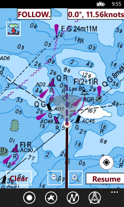

Information
English (United States)
Description
This App offers offline nautical charts,lake & river navigation maps covering Australia for fishing,kayaking,boating & sailing. Coverage includes marine charts,freshwater lake maps & inland river maps. First marine GPS app to have route assistance with Voice Prompts for marine navigation. You can create new boating routes or import existing GPX/KML routes. It supports Nautical Charts course up orientation. Includes Tide & Currents prediction.
►FEATURES √ Offline charts √ Record tracks,Autofollow with real-time track overlay & predicted path vector. √ Voice Prompts for marine navigation (requires GPS ) √ Supports GPX/KML for boating route editing/import. √ Tide & Currents prediction. √ Seamless chart quilting. Map details from Coastal,Approaches,Harbour,Inland Encs(rivers)& general ENC charts are automatically mapped to correct zoomlevel √ Enter or import Waypoints.
► MAPS Get all the details that you find in your chart plotters! Includes unlimited updates for 1 year. Australia
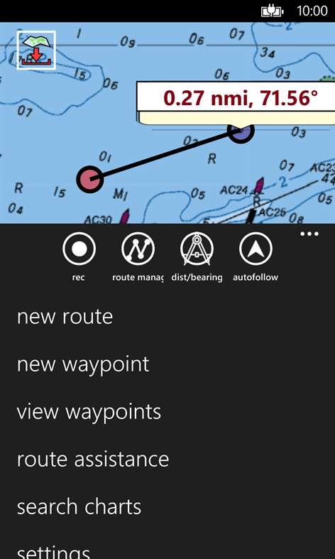
►ROUTE MANAGEMENT / TRIP PLANNING √ Create New Route/Edit Routes √ Reverse Routes √ Enter,Move,Add,Delete,Rename Waypoints √ Import GPX,KML & KMZ files √ Plot/Edit Routes √ Share/Export Routes,Tracks & Markers
►GPS FEATURES √ Auto Follow * Real Time Track Overlay * Predicted Path Vector * Course Up (Text stays upright) * Speed & Heading √ Route Assistance With Voice Prompts * Prompts when approaching a boating route marker * Continous distance & ETA updates * Alerts when sailing/boating off route * Alerts when boating in wrong direction √ Record Tracks
►TIDE & CURRENTS * For US,Canada,UK,Germany&New Zealand * High/Low Tides * Tidal Current Prediction * Active Current Stations
► SHARING * Share tracks/routes/markers on Facebook & Twitter * Export as compressed GPX files.
► Available Folios √Arafura Sea √Australian Antarctic Territory √Bass Strait √Bismarck Sea √Coral Sea √Great Barrier Reef √Gulf of Carpentaria √Indian Ocean √Indonesia / Papua New Guinea √New South Wales √Northern Territory √Papua New Guinea (incl. North East Coast) √Port Phillip √Queensland(Great Barrier Reef & Gulf of Carpentaria) √Solomon Sea √South Australia (Gulf St Vincent & Spencer Gulf) √South Pacific Ocean √Tasmania √Tasman Sea √Timor Sea √Victoria √Western Australia
People also like
Reviews
Articles
Top downloads
- 1
Windows Maps
Free
- 2
gMaps
Free
- 3
GPS Satellite
Free
- 4
MapQuest
Free
- 5
GPS Voice Navigation
Free


New and rising apps
- 1
Stars 3D
$1.49
- 2
NAVIGON Europe
$80.49
- 3
Paris ci la Sortie
$0.99
- 4
SeaMap
$0.99
- 5
Outdoor Navigation
$4.99
- 6
Amsterdam Metro
$0.99
- 7
Altimetro
$0.99
- 8
FirstMate
$4.99
- 9
Bicing Barcelona
$1.49
- 10
City Maps - Vienna
$0.99


Best-rated apps
- 1
Transit Indianapolis
$1.99
- 2
myLocation
$0.99
- 3
Reitit
Free
- 4
Street Views
Free
- 5
MyLocation
Free
- 6
SatelliteMap
$4.99
- 7
Compass
Free
- 8
Geo Converter (Lite)
Free
- 9
Photo Editor India
Free
- 10
Road Trips
Free


Best-rated games
- 1
Sudoku Play & Solve
$0.99
- 2
BoxEmoji
Free
- 3
Drift Mania Championship
$0.99
- 4
Ball don't fall
$1.99
- 5
Hidden Object : Film Ready Action
$1.99
- 6
2 Pics 1 Word - Free
Free
- 7
Hidden Object : Hollywood Crime
$1.99
- 8
Nuclear Warfare
Free
- 9
Funtoon's World HD
Free
- 10
Debonair
Free