 Mobile device
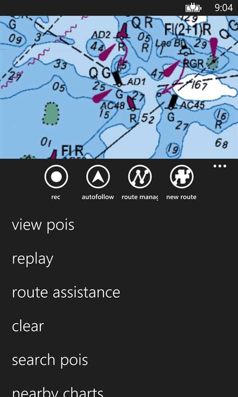

Information
English (United States)
Description
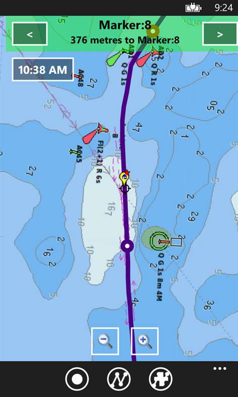
GPS Marine Charts App offers access to charts covering Germany (derived from BSH(Bundesamt für Seeschifffahrt und Hydrographie) data) with POI layers created from ENC charts. Only marine GPS app to have route assistance with Voice Prompts for marine navigation. It has route manager to create new boating routes or import existing GPX/KML routes. It supports Nautical Charts course up orientation. * Voice Prompts for marine navigation (requires GPS ) -prompts when approaching a boating route marker -Continous distance and ETA updates -Alerts when sailing/boating off route -Alerts when boating in wrong direction *** For any question, contact support at gpsnauticalcharts.com / http://www.gpsnauticalcharts.com *** *Route Editing/Creation -Create routes from scratch -Edit existing GPX/KML routes. -Add custom description to any route point. -Drop markers along route. * Offline German charts. Charts are created from BSH ENC data. -Visually draw area to download -Textual search -Catalog (North Sea, Baltic Sea) -Charts reprojected for WGS84 datum *Seamless chart quilting of marine charts *Distance Bearing tool *Create custom way points - Using GPS -Select point on map -Manually enter latitude & longitude coordinates *POI layer for marine charts - Overlay POIs - POI list derived from the equivalent ENC and contains all categories including Buoy, Light, Harbour facility, Obstr. *Search POIs/Way points *Pan/Zoom/My Location * Record Marine GPS tracks * View tracks overlay * Live track animation * Track analytics/stats * Export GPX tracks. -Export to SDCard -Share GPX trakcs with friends/View on Google earth. * Auto Follow Mode (Course up) -Continuously updates boat's location on chart - Adjustable update frequency Sample Nautical Charts
Lauterbach Gager Peenemuende Vierow Ruden Kröslin Wolgast Peenestrom / Negenmark Rinne Peenestrom / Der Strom
People also like
Reviews
Articles
Top downloads
- 1
Windows Maps
Free
- 2
gMaps
Free
- 3
GPS Satellite
Free
- 4
MapQuest
Free
- 5
GPS Voice Navigation
Free


New and rising apps
- 1
Stars 3D
$1.49
- 2
NAVIGON Europe
$80.49
- 3
Paris ci la Sortie
$0.99
- 4
SeaMap
$0.99
- 5
Outdoor Navigation
$4.99
- 6
Amsterdam Metro
$0.99
- 7
Altimetro
$0.99
- 8
FirstMate
$4.99
- 9
Bicing Barcelona
$1.49
- 10
City Maps - Vienna
$0.99


Best-rated apps
- 1
Transit Indianapolis
$1.99
- 2
myLocation
$0.99
- 3
Reitit
Free
- 4
Street Views
Free
- 5
MyLocation
Free
- 6
SatelliteMap
$4.99
- 7
Compass
Free
- 8
Geo Converter (Lite)
Free
- 9
Photo Editor India
Free
- 10
Road Trips
Free


Best-rated games
- 1
Sudoku Play & Solve
$0.99
- 2
BoxEmoji
Free
- 3
Drift Mania Championship
$0.99
- 4
Ball don't fall
$1.99
- 5
Hidden Object : Film Ready Action
$1.99
- 6
2 Pics 1 Word - Free
Free
- 7
Hidden Object : Hollywood Crime
$1.99
- 8
Nuclear Warfare
Free
- 9
Funtoon's World HD
Free
- 10
Debonair
Free