i-Boating: GPS Nautical / Marine Charts - offline sea, lake river navigation maps for fishing, sailing, boating, yachting, diving & cruising
 PC
PC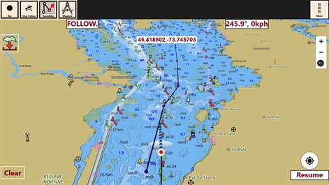


Information
English (United States)
Description
This App offers offline nautical charts, lake & river navigation maps for fishing, kayaking, boating, yachting & sailing. Marine navigation coverage includes marine vector charts, freshwater lake maps, and inland river maps (HD/1ft/3ft bathymetry fishing maps included where available). First marine GPS app to have route assistance for marine navigation. You can create new boating routes or import existing GPX/KML routes. It supports Nautical Charts course up orientation. Includes Tide & Currents prediction.
►FEATURES √ Download Beautiful & detailed Hardware/GPU accelerated vector charts (text stays upright on rotation) √ Query details of Maritime object (Buoy, Lights, Obstruction etc). √ Custom depth(Ft/Fathom/Meter) & distance units (km/mi/NM) √ Custom depth shading (safety depth). √ Record tracks, Autofollow with real-time track overlay √ Voice Prompts for marine navigation (requires GPS ) √ 1ft / 3ft depth contour maps for anglers for selected lake maps. Useful for fishing/trolling(freshwater/saltwater). √ Supports GPX/KML for boating route editing/import. √ Tide & Currents. √ Seamless chart quilting. Map details from Coastal, Approaches,Harbour, Inland Encs(rivers), and general ENC (Electronic Marine Charts) mapped to right zoom √ Enter/import Waypoints.
► MAPS Get all the details that you find in your chartplotters! Includes unlimited updates for 1 year. USA: Maps incl coverage of all NOAA ENC,USACE inland river maps & freshwater lake fishing maps for more than 7K lakes. Charts include HD/1ft/3ft bathymetry where available. Also incl NOAA raster charts for areas where NOAA ENC coverage isn't available. Canada: CHS data including rasters for some regions. Incl Great lakes(US & Canada sides),Alberta & Ontario lakes,Lake Simcoe&Trent Severn Canal. UK/Ireland: UKHO charts Germany:BSH charts,Waterways & rivers. France Europe Inland Rivers:Donau/Danube/Dunaja,Rhine,Rhein,Garonne,Moselle,Drava,Sava Australia Netherland/Holland Croatia Finland Norway Sweden Russia, Ukraine(Black Sea) Brazil Spain Malta, Cypress & S. Mediterranean Sea Caribbean New Zealand Denmark,Greenland,Faroe Seychelles,Mauritius,Tanzania Falklands, Malaysia, South China Sea, Persian/Arabian Gulf,Red Sea South Africa, Argentina, Iceland, Fiji, Estonia,Latvia Turkey,Greece,Italy
►ROUTE MANAGEMENT / TRIP PLANNING √ Create New Route/Edit Routes √ Reverse Routes √ Enter,Move, Add, Delete, Rename Waypoints √ Import GPX, KML & KMZ files √ Plot/Edit Routes √ Share/Export Routes, Tracks & Markers
►GPS FEATURES √ Auto Follow * Real Time Track Overlay * Predicted Path Vector * Course Up (Text stays upright) * Speed & Heading √ Route Assistance With Voice Prompts * Prompts when approaching a boating route marker * Continous distance & ETA updates * Alerts when sailing/boating off route * Alerts when boating in wrong direction √ Record Tracks
►TIDE & CURRENTS * For US, Canada, UK, Germany & New Zealand * High/Low Tides * Tidal Current Prediction * Active Current Stations
► SHARING * Share tracks/routes/markers on Facebook & Twitter * Export tracks/routes/markers as compressed GPX files.
Sample Nautical Charts (See http://gpsnauticalcharts.com/main/folio-catalog-nautical-charts-app for complete list) ... USA: Texas lakes: Eufaula, texoma Florida lakes: Okeechobee Massachussets lakes: Quabbin Wisconsin Lakes: Winnebago Minnesota lakes- Minnetonka, Waconia,Leech,Mille Lacs Maine: Sebago Alaska: Winnipesaukee, Ontario, Huron, Erie, Michigan, Superior TAMPA BAY CHESAPEAKE BAY CAPE CHARLES-NORFOLK HARBOR ANCLOTE KEYS-CRYSTAL RIVER MIAMI HARBOR Keowee,Jocassee,Hartwell,Greenwood,Lake Murray Rainy Lake Quebec to Anticosti Island West Gulf of St. Lawrence South Newfoundland East & South Great lakes Canada & St. Lawrence river Manitoba & Saskatchewan Georgian Bay Gulf of St. Lawrence North-Newfoundland West Puget Sound north sea pacific ocean KEY WEST-MISSISSIPPI SAN PEDRO LAKE MICHIGAN STONY LAKE-POINT BETSIE APALACHICOLA BAY-CAPE SAN BLAS MONHEGAN ISLAND-CAPE ELIZABETH SAN FRANCISCO MIAMI-MARATHON BLACKBURN HURON TAHOE
Canada : Lac Saint Jean Ontario Lakes Rideau Canal- Ottawa River British Columbia Pacific Coast- Vancouver- Haida Gwaii Nova Scotia South- Bay of Fundy
United Kingdom / Ireland: BRISTOL CHANNEL & SOUTH IRELAND ENGLAND S COAST & SCILLIES IRELAND W C-KENMARE R-FORELAND IRISH SEA N&E SCOTLAND-LEWIS-FORTH-N ISLES NORTH SEA-FORTH-THAMES ENTRANCE SCOTLAND KINTYRE-LOCH BROOM THAMES-MEDWAY & APPROACHES
Popular charts/Folios: Rainy Lake and Lake of the Woods Quebec to Anticosti Island West Gulf of St. Lawrence South Ontario Lakes Trent-Severn Waterway Labrador Coast Lac Saint Jean Rideau Canal - Ottawa River Georgian Bay Newfoundland East and South Great lakes Canada and St. Lawrence river Lakes and Rivers in Manitoba and Saskatchewan Lakes and Rivers of British Columbia Pacific Coast - Vancouver Island East & West - Haida Gwaii Lakes around Georgian Bay Gulf of St. Lawrence North - Newfoundland West Alberta Lakes Nova Scotia South - Bay of Fundy GULF OF MEXICO GENERAL CHART OF THE GREAT LAKES CAPE SABLE TO CAPE HATTERAS STRAITS OF FLORIDA AND APPROACHES KEY WEST TO THE MISSISSIPPI RIVER CAPE CANAVERAL TO KEY WEST CAPE HATTERAS TO STRAITS OF FLORIDA NORTH PACIFIC OCEAN EASTERN PART HAVANA TO TAMPA BAY LEASE BLOCK FOR HAVANA TO TAMPA BAY WEST QUODDY HEAD TO NEW YORK-EAST COAST MEXICAN BORDER TO DIXON ENTRANCE NEWPORT TO BERMUDA NANTUCKET SHOALS TO FIVE FATHOM BANK HAVANA TO TAMPA BAY ESTERO BAY-LEMON BAY INCL. CHARLOTTE HARBOR CHESAPEAKE BAY EASTERN BAY AND SOUTH RIVER TAMPA BAY AND ST JOSEPH SOUND TAMPA BAY - PORT RICHEY TAMPA BAY - CLEARWATER HBR FORT MYERS TO CHARLOTTE HARBOR and WIGGINS PASS SANDS KEY TO BLACKWATER SOUND CHEASAPEAKE BAY COVE POINT TO SANDY POINT CHESAPEAKE BAY SANDY PT TO SUSQUEHANNA RIVER ANNAPOLIS HARBOR CHARLESTON LIGHT TO CAPE CANAVERAL INTRACOASTAL WATERWAY MIAMI TO ELLIOTT KEY CAPE MAY TO CAPE HATTERAS CHARLOTTE HARBOR TO TAMPA BAY CHESAPEAKE BAY SEVERN AND MAGOTHY RIVERS TAMPA BAY NORTHERN SECTION MIAMI HARBOR FORT MYERS TO CHARLOTTE HARBOR and WIGGINS PASS TAMPA BAY TO CAPE SAN BLAS FOWEY ROCKS TO AMERICAN SHOAL CHESAPEAKE BAY - MARYLAND CHESTER RIVER CHESAPEAKE BAY CHOPTANK RIVER AND HERRING BAY KENT ISLAND NARROWS Vancouver Island\\Ile de Vancouver, Juan de Fuca Strait to\\a Queen Charlotte Soun Strait of Georgia, Southern Portion\\Partie Sud Lake Ontario\\Lac Ontario LAKE SIMCOE Strait of Georgia, Central Portion\\Partie Centrale (Part 1 of 2) Strait of Georgia, Northern Portion\\Partie Nord Georgian Bay \\ Baie Georgienne Strait of Georgia, Central Portion\\Partie Centrale (Part 2 of 2) North Pender Island to\\a Thetis Island Thetis Island to\\a Nanaimo Juan de Fuca Strait to\\a Strait of Georgia (Western Portion, Part 1 of 2) Howe Sound Active Pass Nanaimo Harbour and\\et Departure Bay Approaches to\\Approches a Vancouver Harbour Haro Strait, Boundary Pass and\\et Satellite Channel Vancouver Harbour, Western Portion\\Partie Ouest Telegraph Harbour and\\et Preedy Harbour Ganges Harbour and\\et Long Harbour Dodd Narrows to\\a Flat Top Islands Baynes Sound Approaches to\\Approches a Sidney Desolation Sound and\\et Sutil Channel Porlier Pass Fraser River\\Fleuve Fraser, Strait of Georgia to\\a Mitchell Island Fraser River\\Fleuve Fraser, Sand Heads to\\a Douglas Island AB Secret Cove and\\et Smuggler Cove Race Rocks to\\a D'Arcy Island Roberts Bank Bedwell Harbour to\\a Georgeson Passage Montague Harbour Pender Harbour Fulford Harbour Sansum Narrows Welcome Passage Vancouver Harbour, Central Portion\\Partie Centrale Shoal Channel Approaches to\\Approches a Nanoose Harbour Jervis Inlet English Channel British Isles The Solent and Southampton Water English Channel Central Part Irish Sea with Saint George's Channel and North Channel British Isles Anvil Point to Beachy Head Saint George's Channel and Bristol Channel Cowes Harbour and River Medina Southampton Water Solent A Beaulieu River Scotland West Coast Bill of Portland to the Needles River Medina Folly Point to Newport Portsmouth Harbour Langstone and Chichester Harbours B Port Hamble to Bursledon Start Point to The Needles including Off Casquets TSS Poole Harbour Newtown River Irish Sea Poole Bay Wootton Creek River Hamble Lymington River Portsmouth Yarmouth Harbour Fareham Lake Sandown Bay Hillhead Harbour Bembridge Thames Estuary Suomi: Norge:kysten Bergen Narvik Florø Risør Oslo Spain: Brazil:MACAU, SALVADOR, RIO, JANEIRO, BARIRI, ITARIRI,Santos, Cabo, Frio Ukraine(Black Sea):Bilhorod-Dnistrovsky Seaport,Illichivsk,Odessa,Yevpatoriya,Mykolaiv,Oktyabrsk,Kherson,Sevastopol,Skadovsk,Feodosiya,Yalta Caribbean:Antigua,Castries,Gustavia,Esquivel,Freeport,Kingston Harbour,Nevis,Port Kaiser,Crooked Island Passage& Exuma Sound,Salt River Anchorage,Speightstown incl. Arawak Jetty,Cuba to Miskito Bank,Basseterre Bay,Bullenbaai,Fuik Baai,Groot Baai,Marigot Harbour,Dominica,Rio Bueno,Scarborough Malta:Ghawdex(Gozo)-Kemmuna,Marsaxlokk,Valletta New Zealand:Tauranga,Lyttelton,Napier,Otago,Wellington
People also like
Reviews
-
3/12/2017GPS Numbers chart by pete
Great app for keeping a list of coordinates and seeing where they fall on a chart. Takes awhile to get use to inputting numbers
-
11/27/2015Easy to download maps by Darrin
Very easy to install new maps. Works great on my Asus laptop.
-
11/21/2015excellent coverage by Darrin
Very easy to use. Make sure to download all grid cells to avoid pixelation.
Articles
Top downloads
- 1
Windows Maps
Free
- 2
gMaps
Free
- 3
GPS Satellite
Free
- 4
MapQuest
Free
- 5
GPS Voice Navigation
Free


New and rising apps
- 1
Stars 3D
$1.49
- 2
NAVIGON Europe
$80.49
- 3
Paris ci la Sortie
$0.99
- 4
SeaMap
$0.99
- 5
Outdoor Navigation
$4.99
- 6
Amsterdam Metro
$0.99
- 7
Altimetro
$0.99
- 8
FirstMate
$4.99
- 9
Bicing Barcelona
$1.49
- 10
City Maps - Vienna
$0.99


Best-rated apps
- 1
Transit Indianapolis
$1.99
- 2
myLocation
$0.99
- 3
Reitit
Free
- 4
Street Views
Free
- 5
MyLocation
Free
- 6
SatelliteMap
$4.99
- 7
Compass
Free
- 8
Geo Converter (Lite)
Free
- 9
Photo Editor India
Free
- 10
Road Trips
Free


Best-rated games
- 1
Sudoku Play & Solve
$0.99
- 2
BoxEmoji
Free
- 3
Drift Mania Championship
$0.99
- 4
Ball don't fall
$1.99
- 5
Hidden Object : Film Ready Action
$1.99
- 6
2 Pics 1 Word - Free
Free
- 7
Hidden Object : Hollywood Crime
$1.99
- 8
Nuclear Warfare
Free
- 9
Funtoon's World HD
Free
- 10
Debonair
Free