 PC
PC Mobile device
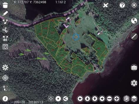

Information
English (United States)
Description
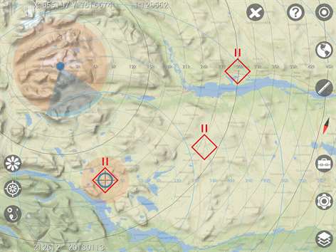
Walter Maps is a professional tool for online and fully offline geodata collection and editing. You can use it stand alone or as a ready-to-use field data collection tool in your existing geodata environment.
The app comes in two flavors, Walter Maps and Walter Maps Pro. Walter Maps contains some editing features, and could be regarded as a reader app for geodata and maps produced by Walter Maps Pro. The target audience for Walter Maps Pro is professional users collecting geodata and producing maps.
In this version, Walter Maps, you can whenever you want unlock the Walter Maps Pro features monthly, i.e. you only pay for Pro functionality when you need it!
Important information about the Pro unlock subscription: - The subscription unlocks the Pro functionality. - This is a monthly subscription. - The price per month is 10 USD. - Payment will be charged to your Windows Store account at confirmation of purchase. - The subscription will not be automatically renewed. - Your account will be charged with 10 USD at renewal. - The subscription does not contain any free trial period.
Walter Maps and Walter Maps Pro contain the following basic features: - No ads - Supports Shape, TIFF, GeoTIFF, JPEG, WMS, WMTS, and TMS - Record waypoints & tracks - Easy measurements of coordinates, lengths and areas - Supports many length and area units, e.g. m, miles, yards, sq.feet, ha, acres etc. - Supports any map projection (projected coordinate system) - Add and delete points, polygons & lines - Collect 2 photos/videos per point, line or polygon feature - View and edit attributes - Create own symbologies (one per map layer) - More than 670 built in symbols for points - Use own point symbols in svg-format - Download single or multiple symbols in svg-format - Create and open map packages - Copy GPS position to clipboard - Use Dropbox for sharing and backup of data - Download layers from http URLs - Multi lingual-support, i.e. create your own language files. Default languages: English and Swedish. - Fully described JSON based map document and map package format.
Walter Maps Pro contains the following additional professional features: - Merge polygon features - Multi part features to single part features - Split polygons by drawn lines or other line layer - Clean polygons - Single step undo of geometry edits - Create new shape files - Add new attribute fields to shape files - Use custom built rules (single or multiple) for creating data collection forms - Tools for assigning date, time, polygon area, line length or polygon perimeter, centroid, UUID, GPS position, cursor position and altitude, compass direction, device pitch and roll to field attributes - Collect any number of photos/videos per feature - Select photos from device album - Import points from text files - Export vector layers to text files or MS Excel (*.xls) - Download layers from pw protected URLs - Email complete map or selected layer - Launch websites based on feature attribute values - Save WMS, WMTS, and TMS layers to offline layers - Use cached WMS, WMTS, and TMS in online mode - Cut and resample raster layers - Export present map view to jpg image - Any number of conditional symbologies, i.e. symbology by field based SQL-queries - Pan to projected or geographic coordinate (x,y or lat,long) - Display distance circles around current GPS position - Display distance circles around cursor position - Display proximity circles around current GPS position and around cursor position - Measure raster values - Copy coordinate for cursor position to clip board - Quickly alternate layers - Local backup of vector data - Energy save mode - Toolbox functions: Distribute sample plots within polygons and along lines
The in app purchase "Unlock Walter Maps Pro" terms of use can be found at: http://waltermaps.com/walter_maps_ppm_terms_of_use/
People also like
Reviews
-
6/6/2017Will not launch. by Thomas Scott
App does not launch.
Articles
Top downloads
- 1
Windows Maps
Free
- 2
gMaps
Free
- 3
GPS Satellite
Free
- 4
MapQuest
Free
- 5
GPS Voice Navigation
Free


New and rising apps
- 1
Stars 3D
$1.49
- 2
NAVIGON Europe
$80.49
- 3
Paris ci la Sortie
$0.99
- 4
SeaMap
$0.99
- 5
Outdoor Navigation
$4.99
- 6
Amsterdam Metro
$0.99
- 7
Altimetro
$0.99
- 8
FirstMate
$4.99
- 9
Bicing Barcelona
$1.49
- 10
City Maps - Vienna
$0.99


Best-rated apps
- 1
Transit Indianapolis
$1.99
- 2
myLocation
$0.99
- 3
Reitit
Free
- 4
Street Views
Free
- 5
MyLocation
Free
- 6
SatelliteMap
$4.99
- 7
Compass
Free
- 8
Geo Converter (Lite)
Free
- 9
Photo Editor India
Free
- 10
Road Trips
Free


Best-rated games
- 1
Sudoku Play & Solve
$0.99
- 2
BoxEmoji
Free
- 3
Drift Mania Championship
$0.99
- 4
Ball don't fall
$1.99
- 5
Hidden Object : Film Ready Action
$1.99
- 6
2 Pics 1 Word - Free
Free
- 7
Hidden Object : Hollywood Crime
$1.99
- 8
Nuclear Warfare
Free
- 9
Funtoon's World HD
Free
- 10
Debonair
Free