 Mobile device
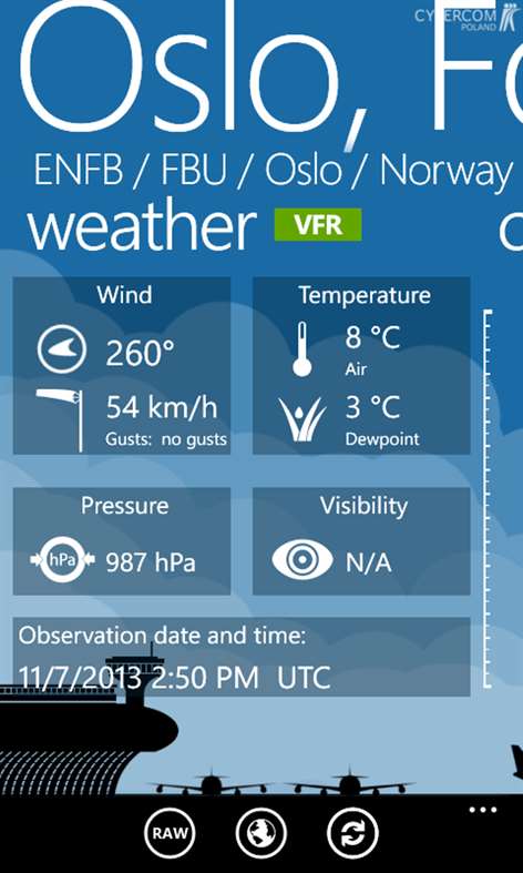

Information
English (United States)
Description
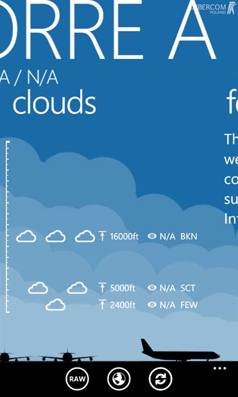
METAR Weather Map is a connection of most current weather reports and maps. It provides information about above 4000 airports all over the world. It is an excellent tool for flight planning, checking METARs, TAFs, NOTAMs and looking for interesting airports or areas with critical flight conditions. It's created by Cybercom Poland for pilots, aviation passionate and people who need accurate weather information. We are a high-tech software consulting company located in Poland. We create software for connected world. Find out more at: http://www.cybercom.pl/ Features: - Beautiful Live Tiles with weather of choosen airports (NEW!) - Special page for Airport info (NEW!) - High contrast mode (NEW!) - Database provides above 4000 airports with details like location, elevation, type of airport, using radio frequencies, departures and arrivals; - METARs, TAFs and NOTAMs - Marking airports on a map with different colors and icons depending on the weather and type of airport - CloudView to visualise cloud layers. - METARs history - Setting pages with fully customized to your preferences units - Searching for airports by ICAO, IATA, City, Country or Name - Dashboard with your favorite airports - Nearby airports - Ability to send raw METAR and TAF by SMS to friends - Ruler mode allows you to measure straight distance between pinned pushpins - Customizable flight's categories (VFR,MVFR,IFR,LIFR) New in version 1.3 (XI.2013) - New LiveTiles - Redesigned User Experience and User Interface - New special page for Airport Info - New unit - distance - Flight Categories added to METAR's history and Forecast - New option: High Contrast Mode - DateTime format depends on the phone settings - Updated airport database - Fixes on Map screen - Fixes on Settings Screen - Fixed redownloading Metars - Fixed calculating of the SeaLevel pressure
People also like
Reviews
-
5/16/2014by User
Very useful. Clean and easy to use
-
12/28/2017Used every day by Brian
Great app. I use this every day as captain at my airline job. Very accurate and fast information. Only complaint is in translation of some lower visibilities are incorrect. For example, an actual METAR may report 2 1/2 SM but is translated to metric as 0.5 which is significantly lower causing the app to assign a LIFR designation to the report. Please fix.
-
5/9/2014by Hosein
Just perfecr, looooove
-
10/17/2016by Kelly
Just feels like it should be more intuitive in nature.
-
9/4/2016by Doug
Revised review: The latest update has resolved most of the problems noted by me and others, so I now give it 5 stars. This is my go-to app for preliminary flight planning. Two problems that persist: 1) the app incorrectly translates METAR data for flight rules into VFR, MVFR, IFR or LIFR. In the USA a ceiling can be either overcast or broken. This app assumes that only an overcast sky is a ceiling. For example, it will identify an airport as VFR when it has visibility of 6 miles and broken clouds at 900 feet. Broken clouds at 900 feet is IFR. 2) updating airport information crashes the app.
-
8/17/2015by michael
Easy to use, great app
-
1/4/2015by Arthur
As a professional pilot, just what you needed. Would be nice if "raw data" could be set as default
Articles
Top downloads
- 1
The Weather Channel
Free
- 2
MSN Weather
Free
- 3
MSN News
Free
- 4
MyRadar
Free
- 5
AccuWeather - Weather for Life
Free


New and rising apps
- 1
Weather26
$1.49
- 2
Meteoservis
$1.19
- 3
Weather and Surf Australia
$3.99
- 4
Smart Weather Pro
$0.99
- 5
Meteoservis Pro
$2.09
- 6
Thermometer
$0.99
- 7
Sun & moon Pro
$1.99
- 8
frost
$1.49
- 9
TileCam
$1.49
- 10
SmarTV
$0.99


Best-rated apps
- 1
China Daily Newspaper
Free
- 2
Duvall Mobile Flood
Free
- 3
Milenio
Free
- 4
Missing Kids Alert
Free
- 5
IT blog
Free
- 6
Weather Update
$2.99
- 7
Telegrafi
Free
- 8
All Economy News Lite
Free
- 9
Android News
Free
- 10
BuzzFeed Reader
Free


Best-rated games
- 1
Sudoku Play & Solve
$0.99
- 2
BoxEmoji
Free
- 3
Drift Mania Championship
$0.99
- 4
Ball don't fall
$1.99
- 5
Hidden Object : Film Ready Action
$1.99
- 6
2 Pics 1 Word - Free
Free
- 7
Hidden Object : Hollywood Crime
$1.99
- 8
Nuclear Warfare
Free
- 9
Funtoon's World HD
Free
- 10
Debonair
Free