Marine Navigation - UK / Ireland - Offline Gps Marine / Nautical Charts for Fishing, Sailing and Boating - derived from UKHO data
 PC
PC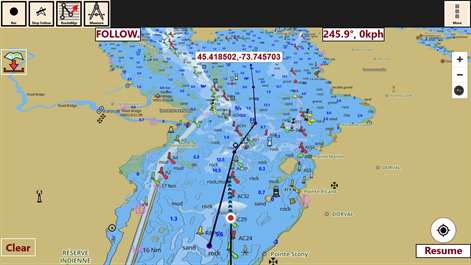

Information
English (United States)
Description
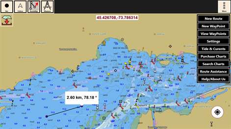
GPS Marine Charts App offers access to RNC charts covering United Kingdom / Ireland waters (derived from UKHO data) with POI layers created from ENC charts. Only marine GPS app to have route assistance with Text Alerts for marine navigation. It has route manager to create new boating routes or import existing GPX/KML routes. It supports Nautical Charts course up orientation. Please visit http://www.gpsnauticalcharts.com/main/uk-nautical-charts-by-folio.html for complete list. If you don't find the chart for United Kingdom / Ireland, please contact us at support at gpsnauticalcharts.com. * Text Prompts for marine navigation (requires GPS ) -prompts when approaching a boating route marker -Continous distance and ETA updates -Alerts when sailing/boating off route -Alerts when boating in wrong direction *Route Editing/Creation -Create routes from scratch -Edit existing GPX/KML routes. -Add custom description to any route point. -Drop markers along route. * Offline charts derived from UKHO data. -Visually draw area to download -Textual search -Catalog (By state, region and coast guard district) -Charts reprojected for WGS84 datum *Seamless chart quilting of marine charts *Distance Bearing tool *Create custom way points - Using GPS -Select point on map -Manually enter latitude & longitude coordinates *POI layer for marine charts - Overlay POIs - POI list derived from the equivalent ENC and contains all categories including Buoy, Light, Harbour facility, Obstr. *Search POIs/Way points *Pan/Zoom/My Location * Record Marine GPS tracks * View tracks overlay * Live track animation * Track analytics/stats * Export GPX tracks. -Export to SDCard -Share GPX trakcs with friends/View on Google earth. * Auto Follow Mode (Course up) -Continuously updates boat's location on chart - Adjustable update frequency Sample Nautical Charts (please visit http://www.gpsnauticalcharts.com/main/uk-nautical-charts-by-folio.html for complete list) The Solent and Southampton Water A Beaulieu River Western Approaches to The Solent Approaches to Portsmouth Bill of Portland to the Needles Bill of Portland to Anvil Point Eastern Approaches to the Solent G Lymington River A Continuation of River Medina Southampton Water and Approaches Outer Approaches to the Solent Port of Southampton Selsey Bill to Beachy Head Approaches to Portland and Weymouth Cowes Harbour and River Medina Berry Head to Bill of Portland A Entrance to River Hamble Thames Estuary B River Medina Folly Point to Newport Portsmouth Harbour D Ashlett Creek H Yarmouth Harbour F Approaches to Keyhaven C Alum Bay E Newtown River Approaches to Felixstowe, Harwich and Ipswich with the Rivers Stour, Orwell and Deben Falmouth to Plymouth G Hillhead Harbour Dartmouth Harbour Poole Harbour and Approaches Poole Bay Falmouth to Truro B Upper Reaches of Beaulieu River Continuation of Fareham Lake I River Yar H Wootton Creek Langstone and Chichester Harbours A Lyme Regis Harbour A Brighton Marina Land's End to Falmouth Portsmouth Harbour Southern Part E Bembridge Harbour A Continuation of Holes Bay Eddystone Rocks to Berry Head A Approaches to Padstow Thames Estuary Northern Part D Freshwater Bay A Helford River Continuation to Gweek Tor Bay Portsmouth Harbour Northern Part J Lizard Point Continuation to Port Solent Start Point to Brixham A Continuation to Blackness Point D Newquay Bay Salcombe to Start Point A Charlestown Harbour Portland Harbour River Thames Sea Reach A Penzance Bay Caernarfon Bay Bristol Channel B Mevagissey Linney Head to Oxwich Point Salcombe Harbour Harwich and Felixstowe Salcombe Approaches to Falmouth B Par Harbour
People also like
Reviews
Articles
Top downloads
- 1
Translator
Free
- 2
GasBuddy
Free
- 3
Compass
Free
- 4
Uber
Free
- 5
TripAdvisor
Free


New and rising apps
- 1
Wifi Map Pro
$0.99
- 2
Speech To Text
$0.99
- 3
wMetanoauto
$2.99
- 4
Het Verkeer
$1.99
- 5
Offline Maps
$1.49
- 6
Warsaw Pocket Guide
$1.99
- 7
Holiday and Vacation Countdown Widget
$1.99
- 8
Flight Stats
$0.99
- 9
Vegan Passport
$2.25
- 10
Traffic and Travel UK
$0.99


Best-rated apps
- 1
HereAbout
Free
- 2
100 NTO
Free
- 3
Travel to East Java
Free
- 4
Share Location
Free
- 5
Amazing Places
Free
- 6
HSL Mobiililippu
Free
- 7
Baloch and Balochistan
Free
- 8
Fly With Biman
Free
- 9
Pakistan Tourism
Free
- 10
MAJESTIC INDIA
Free


Best-rated games
- 1
Sudoku Play & Solve
$0.99
- 2
BoxEmoji
Free
- 3
Drift Mania Championship
$0.99
- 4
Ball don't fall
$1.99
- 5
Hidden Object : Film Ready Action
$1.99
- 6
2 Pics 1 Word - Free
Free
- 7
Hidden Object : Hollywood Crime
$1.99
- 8
Nuclear Warfare
Free
- 9
Funtoon's World HD
Free
- 10
Debonair
Free