 Mobile device
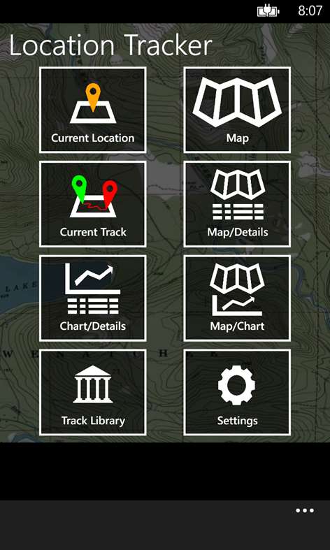

Information
English (United States)
Description
*** New *** Charting has been expanded to allow you to chart either elevation or speed against either distance or elapsed time!
Location Tracker allows you to take advantage of your device’s GPS receiver, and Nokia’s maps or Google’s maps, to track your location wherever your adventures take you! You can create, view, edit, upload and download GPX tracks enabling you to be even more engrossed in your travels and relive them later.
Key features: - Utilizes Nokia Maps and Google Maps. You get to choose which data source you prefer: - Nokia Maps allows map access offline, without a data connection. - Google Maps provides superior topographic support, but might require a data connection.
- Background location tracking. Tracking continues even after you press the Start button and launch other apps. Just re-launch Location Tracker and you will pick up where you left off – complete with all the position changes that were recorded while you were gone.
- Elevation or speed data can now be charted against either distance or elapsed time. You can also zoom in and out on the chart itself to see more details. The charts are accompanied with either full details of all tracks, or with the map. Selecting tracks is possible on the charts and stays in sync with the track table or associated map.
- Track your current location with details such as: - Elevation - Speed - Heading - Latitude - Longitude
- View summary information about your current track, such as: - Elapsed time - Distance - Number of track points - Elevation min, max and range - Speed max and average - Pace average - Latitude and longitude min/max - Context menu support for saving your current track - Context menus allow you to select the point associated with your elevation extremes, latitude/longitude extremes, and maximum speed. Once selected, you can easily see where these events occurred on the various maps, charts, and details pages.
- View details about every point on the current track, such as: - Time - Distance from start - Elapsed time - Latitude - Longitude - Elevations - Speed - Heading - Context menu support to delete points that your GPS device misplaced
- Upload and download .gpx files to/from OneDrive. GPX file versions 1.0 & 1.1 can both be viewed!
- Map styles supported: - Topographic - Satellite - Street - Satellite/Street hybrid
- Distance units supported: - Feet/miles - Meters/kilometers
- Latitude/Longitude formats supported: - Degrees - Degrees/minutes - Degrees/minutes/seconds
- Heading formats supported: - Degrees - Cardinal/ordinal (N/NE/E/…)
- Map Tracking: - Automatically reposition map when necessary - Always re-center map as you move - Or, off allowing you to control the map manually
- Chart x-axis value options: - Distance - Elapsed time
- Chart y-axis value options: - Elevation - Speed
Please send feature requests and questions to [email protected]. You can use the About menu item on the Main page to help you out.
People also like
Reviews
-
5/10/2015by Mark
Of all the mapping/tracking apps I've downloaded, this is the one I turn to. I'm a nerd who loves the outdoors & playing with maps and this app does almost everything I'd want. Simple, easy to use, great charts (I really like the way it labels the charts - makes it very easy to read), usage flows cleanly between the various features. Contrary to one of the other reviews, this app does continue to collect data if I switch to another app. It's very cool that I get to choose the map source - either Google or Nokia! All that's missing is for the offline Nokia maps to include topographical data - hopefully Nokia will fix that.
-
8/18/2015by Kevin
Great app! Can export gpx files!
-
5/9/2015by Sue
I just love playing with this app! I use it on every hike to track where we currently are and then revisit the hike at home over and over again. Often when contemplating our next hike, I go back to my previously saved tracks to check out time, distance and elevation for planning purposes. The new charting of elevation or speed verses time or distance is very cool. I even play with this app to track our progress while flying - although the phone will sometimes lose the GPS mid-flight, but that is not this app's fault.
-
6/16/2014by Winston
Does as it says on the tin, works good so far. Please allow the user to choose which folder on the phone to save the gpx files, SkyDrive integration is nice but with 8.1 and file management and ability to upload from browser it'll be cool to have access to the files
-
10/12/2014by User
Works great with one major flaw. While using the program to track your location, the use of any other program can shut down the tracking program. You will either have to start it again or leave it stopped. If you keep turning it on and having it shut down by use of another program, you end up with multiple tracks. This can make it extremely difficult to try and map any hike or trail traveled. If this bug was fixed, I'd give it a 6 star rating!
Articles
Top downloads
- 1
Windows Maps
Free
- 2
gMaps
Free
- 3
GPS Satellite
Free
- 4
MapQuest
Free
- 5
GPS Voice Navigation
Free


New and rising apps
- 1
Stars 3D
$1.49
- 2
NAVIGON Europe
$80.49
- 3
Paris ci la Sortie
$0.99
- 4
SeaMap
$0.99
- 5
Outdoor Navigation
$4.99
- 6
Amsterdam Metro
$0.99
- 7
Altimetro
$0.99
- 8
FirstMate
$4.99
- 9
Bicing Barcelona
$1.49
- 10
City Maps - Vienna
$0.99


Best-rated apps
- 1
Transit Indianapolis
$1.99
- 2
myLocation
$0.99
- 3
Reitit
Free
- 4
Street Views
Free
- 5
MyLocation
Free
- 6
SatelliteMap
$4.99
- 7
Compass
Free
- 8
Geo Converter (Lite)
Free
- 9
Photo Editor India
Free
- 10
Road Trips
Free


Best-rated games
- 1
Sudoku Play & Solve
$0.99
- 2
BoxEmoji
Free
- 3
Drift Mania Championship
$0.99
- 4
Ball don't fall
$1.99
- 5
Hidden Object : Film Ready Action
$1.99
- 6
2 Pics 1 Word - Free
Free
- 7
Hidden Object : Hollywood Crime
$1.99
- 8
Nuclear Warfare
Free
- 9
Funtoon's World HD
Free
- 10
Debonair
Free