 PC
PC Mobile device
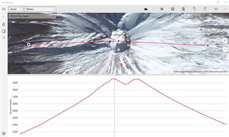

Information
English (United States)
Description
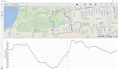
Geo Elevation is a powerful tool to build a cross-sectional elevation chart from any paths/points on the map with a few clicks. Simply create a path and click on "Get Elevation" you will see a nice chart.
How does Mt. Everest look like if you cut through the peak, and view it from the side? Try to draw a path from your place to the nearest shoreline. See how slope decline as it approach the ocean? How about investigating the Mariana Trench's steep slope, which goes down to the deepest place on the Earth?
In addition, the line of the elevation profile is clickable to indicate corresponding location on the path that you draw.
[Features] - Get Elevation from single point - Get Elevation from a path - Path will automatically allocate 100 points (really high-definition of elevation profiles!) - Export raw data in CSV format - Export the path in KML - Single-click to export all formats - Indicator to match the side view and the top view - Current Location On/Off - Draggable Waypoints (Adjust the path later) - State of art intuitive path draw tool - Universal binary works both Windows Phone 10/ Windows 10 desktop. - Unlimited Undo / Redo - Convenient "Clear All" button to reset - Navigation Mode (Lock the screen to browse) - Search location to zoom the target location quickly
[Usage] - As a bike / running route builder: It's convenient to research your bike road profile in order to figure out the schematics of hills.
- Mobile Learning Experience in the Classroom. If you are teaching Geology or Earth Science, you might have a handout to build a cross-sectional elevation chart from a contour map, and you can let students to verify their answer by themselves. Don't forget, Geo Elevation will provide infinite locations to investigate! The usage is unlimited.
- Possible flood area investigation: Before storm surge or high tide hit your town, verify locations or road that could be flooded. Draw the path from your house to the nearest shoreline to see the vertical profile.
- Plan your Walk or Run: If you host a walk or run event, Geo Elevation will help you to find out the slope so that you can map challenging hill in your event. Additionally, it might help you to setup multiple routs depend of the slope.
- For hiker and mountaineers (send us your review if you used for your activities!)
Add your feedback in comments or send us email to info [-at-] objectgraph.com.
We would like to hear more user experiences! How did you use it? What did you use it for? Is there anything to improve?
People also like
Reviews
-
1/27/2017Useless by Barry
Incomplete mapping. No topo. Keeps sending me back to New York. At least Google allows an uninstall and refund within 24 hrs. Like other windows apps not worth any amount.
-
9/18/2015Good Educational tool by Gavi
I used it to find the cross section of Mt. Everest, check why super storm sandy inundated my neighborhood and checked out the elevation at the beach in Malibu. Very Nice!
-
9/19/2015Good for Educational Purpose and Daily Usage by Takeuchi
I was able to display the elevation profile across continental shelf. Cool! For daily walk and bike path, I check how steep the slope is.
-
9/19/2015Awesome by Sergei
Love this app!
Articles
Top downloads
- 1
Windows Maps
Free
- 2
gMaps
Free
- 3
GPS Satellite
Free
- 4
MapQuest
Free
- 5
GPS Voice Navigation
Free


New and rising apps
- 1
Stars 3D
$1.49
- 2
NAVIGON Europe
$80.49
- 3
Paris ci la Sortie
$0.99
- 4
SeaMap
$0.99
- 5
Outdoor Navigation
$4.99
- 6
Amsterdam Metro
$0.99
- 7
Altimetro
$0.99
- 8
FirstMate
$4.99
- 9
Bicing Barcelona
$1.49
- 10
City Maps - Vienna
$0.99


Best-rated apps
- 1
Transit Indianapolis
$1.99
- 2
myLocation
$0.99
- 3
Reitit
Free
- 4
Street Views
Free
- 5
MyLocation
Free
- 6
SatelliteMap
$4.99
- 7
Compass
Free
- 8
Geo Converter (Lite)
Free
- 9
Photo Editor India
Free
- 10
Road Trips
Free


Best-rated games
- 1
Sudoku Play & Solve
$0.99
- 2
BoxEmoji
Free
- 3
Drift Mania Championship
$0.99
- 4
Ball don't fall
$1.99
- 5
Hidden Object : Film Ready Action
$1.99
- 6
2 Pics 1 Word - Free
Free
- 7
Hidden Object : Hollywood Crime
$1.99
- 8
Nuclear Warfare
Free
- 9
Funtoon's World HD
Free
- 10
Debonair
Free