
 PC
PC Mobile device
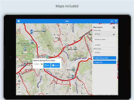

Information
English (Australia)
Description
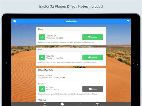
ExplorOz Traveller is an Australian navigation, mapping and tracking app designed for use on devices with a GPS. Produced by the developers of ExplorOz.com, the app uses the very latest 2018 Release EOTopo maps, which you can use online or offline. It also includes all the trip planning resources you’ll ever need – with a Places & Treks database providing 90,000 waypoints, POIs, and 180 Trek routes.
Once you get out on the road, you’ll appreciate how easy it is to use – you literally don’t need to plan a thing before you go because all the maps and resources you need are already loaded into the app for your convenience. The most significant part of this is you’ll notice how easy it is to make a change of plan and how easy it is to find your way around an area you are unfamiliar with. ExplorOz Traveller takes the stress away from your trip planning and on-the road lifestyle, yet gives you everything you could ever want from a GPS navigator and much more.
HOW TO LOAD MAPS As soon as you load the app, it will prompt you to setup and load the necessary maps and resource files. The app utilises both online and offline maps. Only EOTopo maps accessible through the Data Manager can be used offline. The Base Offline Map is a whole of Australia map, with a max zoom of Level 10, which has a map scale of 1:2.3M. You will also need to download the additional zoom levels available in the Premium Map Pack to enable the map to zoom to Level 14, which has a map scale of 144K.
HOW THE APP USES MAPS When you open the Map from the Home Screen of the app, it will centre on your current position (with GPS lock turned on). The Map Layer tool allows you to switch between a selection of 3 different online maps (EOTopo™, Streets & Paths, Satellite). These are free and you don’t need to download anything. The EOTopo online map is the very latest 2018 update and has a maximum zoom scale of 18K, which is the most detailed online topographic map of the whole of Australia available.
If internet drops out, the app will automatically display the offline map (EOTopo™). The map also includes 90,000 interactive markers showing you the exact location of free camps, caravan parks, road houses, caves, graves, bores, boat ramps, medical services, airstrips, and more! These Places can be clicked to view photos, read descriptions, traveller-submitted comments, and to activate the "Go To" navigation control.
You have the option to display the Snail Trail feature which draws a line on the map showing the path you travel. The Snail Trail will continue to record and display until you clear it. Snail Trail cannot be saved, stored, or shared.
EXTRA FEATURES The app also contains 180 Treks, which are routes for all the well-known 4WD tracks, plus many interesting trails suitable for caravans, and camper-trailers. Treks include information for safety, planning and preparation. Treks can be selected for "Go To" navigation, which provides offline auto guidance.
You can also create your own Treks for offline auto-guidance, however an internet connection is required to generate driving directions that follow the path of roads so these need to be done and saved in advance before you leave the grid.
Tracking is an extra feature exclusively for ExplorOz Members only. When tracking is enabled, the app records and stores position data as you travel and sends this to the ExplorOz server where a map is displayed showing the path of your travel, with overnight stop markers, and travel statistics. If your device is not online during tracking, the app will still track and record your journey accurately. You can also provide access for family/friends to view your ExplorOz tracking. Tracking can also be saved, downloaded or shared.
OPERATIONAL TIPS This app requires use of a GPS as a Windows sensor. You can either use a device with inbuilt GPS or connect to a compatible GPS. Serial or USB based GPS devices may require the use of a GPS sensor driver (we recommend GPSComplete available from https://www.turboirc.com/gps7/).
People also like
Reviews
Articles
Top downloads
- 1
Windows Maps
Free
- 2
gMaps
Free
- 3
GPS Satellite
Free
- 4
MapQuest
Free
- 5
GPS Voice Navigation
Free


New and rising apps
- 1
Stars 3D
$1.49
- 2
NAVIGON Europe
$80.49
- 3
Paris ci la Sortie
$0.99
- 4
SeaMap
$0.99
- 5
Outdoor Navigation
$4.99
- 6
Amsterdam Metro
$0.99
- 7
Altimetro
$0.99
- 8
FirstMate
$4.99
- 9
Bicing Barcelona
$1.49
- 10
City Maps - Vienna
$0.99


Best-rated apps
- 1
Transit Indianapolis
$1.99
- 2
myLocation
$0.99
- 3
Reitit
Free
- 4
Street Views
Free
- 5
MyLocation
Free
- 6
SatelliteMap
$4.99
- 7
Compass
Free
- 8
Geo Converter (Lite)
Free
- 9
Photo Editor India
Free
- 10
Road Trips
Free


Best-rated games
- 1
Sudoku Play & Solve
$0.99
- 2
BoxEmoji
Free
- 3
Drift Mania Championship
$0.99
- 4
Ball don't fall
$1.99
- 5
Hidden Object : Film Ready Action
$1.99
- 6
2 Pics 1 Word - Free
Free
- 7
Hidden Object : Hollywood Crime
$1.99
- 8
Nuclear Warfare
Free
- 9
Funtoon's World HD
Free
- 10
Debonair
Free