
 Mobile device
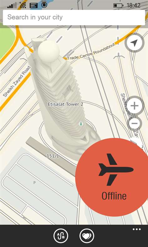


Information
Русский (Россия) Čeština (Česká Republika) English (United States) Español (España Alfabetización Internacional) Українська (Україна)
Description
2GIS — Offline maps and business listings. Verified information about restaurants, bars, hotels and any location with photo and review. Helpful travel guide. Navigation: get car directions, public transport routes including metro.
2GIS provides 3D-maps of 180+ cities, contacts of 1.5 million companies, car routing and public transport routes and and more! 2GIS is a complete and up-to-date directory of organizations with detailed cities’ maps. 2GIS provides verified information only.
The app can operate offline even without mobile data plan!
75 major metro areas available for download:
UAE (Dubai), Cyprus (Lefkosia, Lemesos), Italia (Padova, Venezia), Czech Republic (Prague), Chile (Santiago), Moscow, St. Petersburg, Abakan, Almaty, Arkhangelsk, Astrakhan, Barnaul, Belgorod, Biysk, Blagoveshchensk, Bratsk, Bryansk, Veliky Novgorod, Vladivostok, Vladimir, Volgograd, Vologda, Voronezh, Gorno-Altaisk, Donetsk, Yekaterinburg, Ivanovo, Izhevsk, Irkutsk, Yoshkar Ola, Kazan, Kaliningrad, Kaluga, Kemerovo, Kirov, Kostroma, Krasnodar, Krasnoyarsk, Kurgan, Kursk, Lipetsk, Magnitogorsk, Naberezhnye Chelny, Nizhnevartovsk, Nizhny Novgorod, Nizhny Tagil, Novokuznetsk, Novosibirsk, Odessa, Omsk, Orenburg, Perm, Penza, Prague, Rostov-on-Don, Ryazan, Samara, Saratov, Smolensk, Sochi, Stavropol, Stary Oskol, Sterlitamak, Surgut, Syktyvkar, Tver, Tolyatti, Tomsk, Tula, Tyumen, Ulan-Ude, Ulyanovsk, Ufa, Khabarovsk, Cheboksary, Chelyabinsk, Chita, Yakutsk, and Yaroslavl.
2GIS provides:
- Verified information on over 1.5 million organizations (including public institutions such as hospitals, schools, police stations, and etc.): - Addresses, phone numbers, e-mail addresses, websites, working hours and payment methods; - Detailed 3D maps with such attributions as – buildings’ amount of floors, driveways, kiosks and fences; - Car routing and searching for public transportation routes with transfers and pedestrian crossings.
2GIS allows you to:
- Find the location of the company you are looking for, find out its phone number and make a call; - Find a desired location on the map of the city: a building (using its address), a public transport station or just a well-known object; - Tap on any building on the map and find out its address, amount of floors and organizations that reside there; - Find all companies in a specific business area, view them on the map, and filter out the ones that are open at a convenient time or right now; - Find how to get to your destination by car or by public transport; -Identify your location and find out what is close to you.
Once 2GIS is installed, select the city you need to download the data. The application does not require Internet connection to operate with the directories and maps. Afterwards you can receive the most up-to-date information every month with just one tap using the built-in automatic update system.
Business listings are verified by 2GIS’s own call-center and ‘field teams’, who update the databases on a monthly basis. 2GIS maps are created by professional cartographers based on up-to-date satellite images and with regular on-site verification.
People also like
Reviews
-
5/13/2015by Aleksandr
Теперь оффлайн. Молодцы
-
5/14/2015by Мухаммад
Оффлайн уже есть!!!!
-
6/12/2017Добавьте дополненную реальность и транспорт на карте! by андрей
Добавьте AR - дополненную реальность,когда при наведение камеры на окружающее пространство на экране обозначаются ближайшие организации (кафе,аптеки и т.п.).Естественно,режим будет работать при включенном GPS/ГЛОНАСС.Добавьте слежение за транспортом онлайн и дополненную реальность!Обставьте Яндекс! P.S. Добавьте версию под ПК/планшеты - тем более их доля среди планшетов высока!
-
6/30/2016REALLY GOOD MAP by Storozhenko
I finally found map that is usable (and has all features I need) in Dnipropetrovsk. ---------- But the longer I use it, the worse it appears. Some suggested routes are false. Walking routes are not available. Interface is a little difficult, and not native for WM. Performance is not perfect, especially in 3d mode. At this moment I prefer Yandex Maps (which probably works in online mode only)
Articles
Top downloads
- 1
Translator
Free
- 2
GasBuddy
Free
- 3
Compass
Free
- 4
Uber
Free
- 5
TripAdvisor
Free


New and rising apps
- 1
Wifi Map Pro
$0.99
- 2
Speech To Text
$0.99
- 3
wMetanoauto
$2.99
- 4
Het Verkeer
$1.99
- 5
Offline Maps
$1.49
- 6
Warsaw Pocket Guide
$1.99
- 7
Holiday and Vacation Countdown Widget
$1.99
- 8
Flight Stats
$0.99
- 9
Vegan Passport
$2.25
- 10
Traffic and Travel UK
$0.99


Best-rated apps
- 1
HereAbout
Free
- 2
100 NTO
Free
- 3
Travel to East Java
Free
- 4
Share Location
Free
- 5
Amazing Places
Free
- 6
HSL Mobiililippu
Free
- 7
Baloch and Balochistan
Free
- 8
Fly With Biman
Free
- 9
Pakistan Tourism
Free
- 10
MAJESTIC INDIA
Free


Best-rated games
- 1
Sudoku Play & Solve
$0.99
- 2
BoxEmoji
Free
- 3
Drift Mania Championship
$0.99
- 4
Ball don't fall
$1.99
- 5
Hidden Object : Film Ready Action
$1.99
- 6
2 Pics 1 Word - Free
Free
- 7
Hidden Object : Hollywood Crime
$1.99
- 8
Nuclear Warfare
Free
- 9
Funtoon's World HD
Free
- 10
Debonair
Free